Posts

Showing posts from June, 2015

IMET Blog Post: Washington Fire Weather Decision Support

Image
Hey everyone! I’m out here working on the Washington Fire near Markleeville, CA as an I ncident Met eorologist, or “IMET” for short. I was dispatched to support an Incident Management Team from the Great Basin that has been assigned to manage the fire suppression efforts for the Washington Fire. As the IMET, I give direct decision support to the Incident Commander and the rest of the wildland firefighters that are working hard to contain this fire.   Courtesy of Sierra Front Wildfire Cooperators One of my primary functions is to keep the firefighters informed on weather conditions that are favorable for suppression efforts such as letting them know about light winds that were going to be favorable for their firefighting efforts earlier this week. With that information, the team was able to put together a plan that was very aggressive for fighting the fire directly with many hand crews and fire engines, taking advantage of the favorable weather. On the other extreme, I also let

Guest Post by Washoe County Air Quality: Wildfire Smoke in Northern Nevada

Image
Special thanks to Washoe County Air Quality for being our first Guest Post! Enjoy! - NWS Reno  Wildfires happen in the Sierra Nevada every year. The intensity and frequency of wildfires has been exacerbated with the increasingly dry conditions during the exceptional drought period across California and Nevada. If you are not close enough to the fire to be concerned with life and property, the next concern is your health in relation to smoke from wildfire. Let's take a look back at how much fine particulates ( PM 2.5 ) foun d in smoke has impacted the Northern Nevada region.  Here are the top three 24-hour average  PM 2.5  air quality indexes (AQIs) for downtown Reno (2000-2015):  1. CA Wildfires 6/25/08 - AQI 182 Unhealthy 2. King Fire 9/18/14 - AQI 174 Unhealthy 3. Rim Fire 8/23/13 - AQI 169 Unhealthy For all three wildfire events, Northern Nevada experienced several days to over a week of smoke impacts above the 24 hour average National Ambient Air Quality Stand

Forecasting "Dry Microburst" Potential From Soundings and Observations

Image
Summer afternoons in the valleys of eastern California and western Nevada usually feature dry low level relative humidity. In certain cases where low levels are very dry (single digit relative humidities) and enough instability for showers and/or thunderstorms exists, there is the heightened possibility for severe (over 60 mph) outflow winds. Now, severe winds are possible from strong thunderstorms in many cases, even without very dry surface relative humidity. However, what makes very dry surface or low level conditions special is that severe outflow winds are possible even with w eak  convection such as light showers...or even just cumulus clouds! When severe winds are produced by convection with little or no rainfall reaching the ground, it is referred to as a "dry microburst". Microbursts can be of significant danger to aviation and, if they are strong enough, life and property. Before we move onto what conditions we look for to determine the threat for dry microbursts,

We Got a Lot of Rain in May...Where Does This Leave Us?

Image
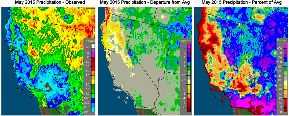
After a brutally dry winter, May finally brought some welcome precipitation to the region. Now, where exactly does this leave us? Is the drought over? In a word, No. Does the recent rain and high elevation snow help? Most definitely! The rain did bring a bit of a recharge to area lakes, rivers, and reservoirs, but the relief is unfortunately short-lived. What we really need is a deep snowpack to slowly replenish water storage...of course with it being nearly June, we are out of time this season. So, how did May 2015 stack up across California and Nevada...see for yourself below: The greatest departures from average were through Mono County due to a snowfall event on May 8 which brought over a foot of snow (and liquid equivalents of 1-2 inches) to many locations. Here are some incredible photos and snow totals from the event: June Lake - Photo Courtesy of Michael Cohen McGee RV Park Across from Crowley Lake - Photo Courtesy of Anna Maier After starting the month wi