Posts

East Wind Events: Windy Up "There", Not-So-Windy Down "Here"

Image
Gusty Ridges, Calm Valleys.  We have gotten a lot of questions lately about why it's so windy up in the mountains and why there are  no winds down in the valleys, so we figured we would write up a quick blog post about it. Let's talk  observations...these are just a spattering of observations from an event we had this week  (Dec 6-8, 2020). Notice the big difference between the ridges and the valley locations.  Let's not get stuck on the actual numbers at the ridges, since some of those sensors can get a little 'off' once wind speeds really pick up, the more important thing to note is the large differences in the wind  gusts from ridges to foothills to valleys. (note obviously Peavine was having a bit of trouble too)  We want to dig into how this occurs and why it happens! So if you're brave and ready for some science,  then continue onward. General Weather Setup  It is a well known set up and similar to previous events, but the magnitude of...
Climate News - September 2020

Image
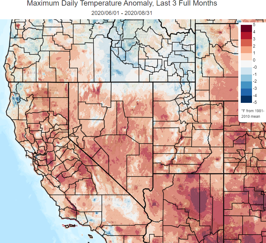
Hope everyone has been doing as well as possible! For this newsletter, we will begin with the usual summary of regional climate features over the past few months. That will be followed by a look at abnormally warm ocean waters, also known as a “marine heat wave”, which have set up across the North Pacific. Finally, we’ll throw in a few words about climate averages from The National Centers for Environmental Information which are due to be updated by the middle of next year. Note: If you have any questions or would like clarification on what is presented in this newsletter, feel free to message us on Facebook ( https://www.facebook.com/NWSReno/ ) or email w-rev.webmaster@noaa.gov ________________________________________________________________________________ So, what’s been happening from a climatological perspective across northeast California, the Sierra, and western Nevada? Summer high temperatures ran considerably above average when compared with the averages from 1981-2010 (the la...

Climate News - April 2020

Image
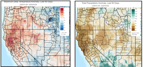
  CLIMATE NEWS April, 2020 Hello folks! The National Weather Service in Reno hopes you are doing well during these unusual times.  This will be the first edition of a periodic newsletter that will contain summaries of various aspects of the climate, mainly across northeast CA, the Sierra, and western NV but sometimes on a continental or global scale.   NOTE : if you have any questions or would like clarification on what is presented in this or future newsletters, feel free to shoot us a message on Facebook ( https://www.facebook.com/NWSReno/ ) or email w-rev.webmaster@noaa.gov Alright, let’s start with a summary of the recent precipitation and temperature trends around the region. Here are a couple maps showing that the region has generally been warmer than average temperature-wise (+1.6 degrees at Reno) with well below average precipitation (48% Reno) since late January. Source: https://climatetoolbox.org/ The notable lack of precipitation has led to a below average...

El Nino: Recent Science and Forecast For Winter 2018-2019

Image
SUMMARY POINTS: 1. EL NINO DOES NOT ALWAYS MEAN A WET WINTER FOR CALIFORNIA! Warming of the tropical Pacific Ocean with El Nino (or cooling with La Nina) is one of the only predictable features for seasonal (beyond 1-2 months) precipitation forecasting. Climate scientists know there are other features that affect winter precipitation; however, they are not predictable beyond a couple weeks or so. Depending on El Nino/La Nina alone can lead to large seasonal forecasting errors for California winter precipitation. 2. EL NINO NOT USUALLY MUCH HELP PREDICTING WINTER PRECIPITATION IN NORTHEAST CALIFORNIA AND WESTERN NEVADA. A weak-moderate El Nino is expected for the winter of 2018-2019. That strength El Nino does not provide much help for forecasting winter precipitation for the northern and central Sierra, northeast California, and western Nevada...with only the strongest El Nino events nudging chances for higher precipitation up slightly . Therefore, there are equal chances for abo...

Hiking in the High Sierra? Attn: PCT through hikers!

Image
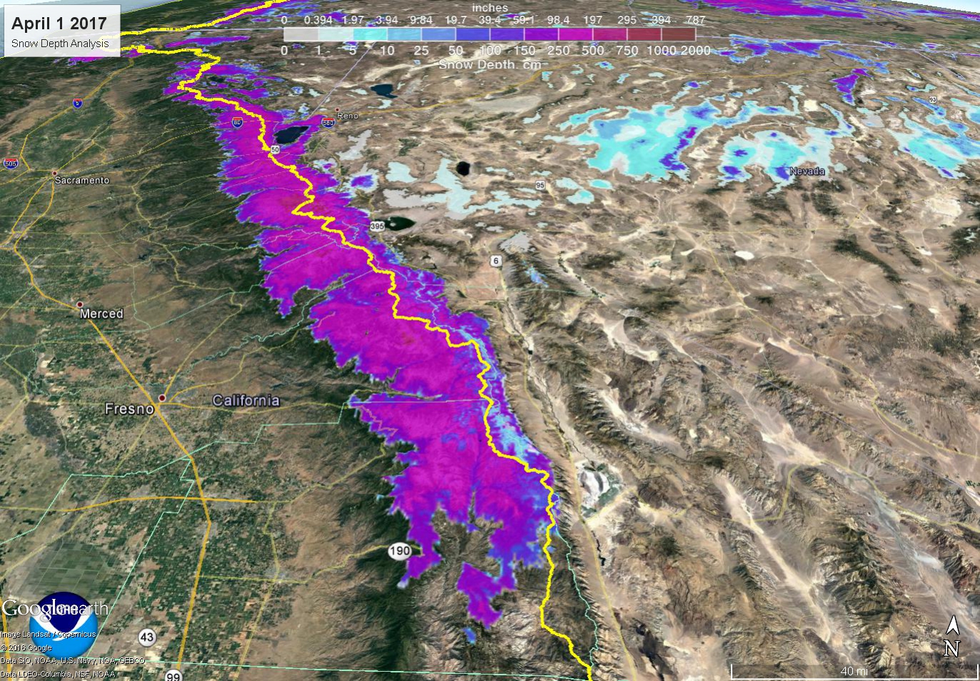
Let's Talk Total Snow Amounts Our reliable snowfall measurement sites in the Sierra, certainly near the PCT, are very limited. So it would be better to show a map of snow depth using automated sensors and satellite data. This was taken on April 1, typical peak snowpack date. Values of 16-25 feet were fairly common along the PCT from near Tahoe to southwest of Bishop! Here’s June 8th's plot for comparison Yellow line = PCT Mammoth Mountain in January alone received 20.5 feet of snow, earning the month the Twitter hashtag #januburied. Of course snowfall was variable, but on a big picture this was a particularly impressive season for the Sierra from Tahoe to Bishop. The section between Tioga/Tuolumne and Sonora Passes got particularly crushed . That’s where some of the deepest snowpack still exists. A snow measurement by Jeff Anderson, NRCS, and Tim Bardsley, NWS, made just Tuesday at Leavitt Lake near Sonora Pass - 15 feet deep, containing 102.5 inches of water conte...