Meteorological vs Astronomical Fall and a quick Summer 2015 Overview
Let's take a look back at Summer 2015. Although astronomical fall hasn't begun, meteorological summer has ended. What? There is a bit of a difference between the two. Astronomical summer ends (or fall begins) when the Autumnal Equinox occurs, around September 22-23 (specifically September 23, 2015 at 8:20 UTC in the northern hemisphere) So why would meteorological summer end (or fall begin) at a different time? It's basically because the astronomical seasons are based on the Earth's position related to the Sun while the meteorological seasons are based on the temperature cycles through the year. For a more in depth discussion on what the difference is between the two, check out this great write-up by NOAA's NCEI (National Centers for Environmental Information).


Anyways, back to the Summer summary for Reno. Looking back at the summer, we had a VERY active monsoon pattern which resulted in multiple days of thunderstorms and flooding for the Sierra and western Nevada. The most active period was during late June and early July where we received multiple reports of flash flooding, hail, and quite a bit of rain and lightning! We even had a waterspout at Lake Tahoe! Here are just a few of the pictures from some of the summer thunderstorms.

This active period of weather kept temperatures relatively "cool" compared to normal for that late June and early July time frame. We typically will see some of our hottest temperatures during July but due to the cloud cover from thunderstorms we didn't see as many triple digit days. The chart below shows the amount of days that Reno airport hit 100 degrees or more during June, July, & August since 1996. One thing to keep in mind is that this chart only shows the temperature for the Reno airport since that is the official climate site that we use for the Reno area. You can really see that 2014/2015 didn't have nearly as many 100 degree or hotter days as 2013 did!
 Let's take a look at July though. July historically is the hottest time of the year for the Sierra and western Nevada so let's compare previous July 100 degrees and hotter days. Here you can really see a difference. On average we will hit 100 degrees or hotter at the Reno airport around 4 times during July and we only did twice in 2015. Also notice how many more times 100 degrees or hotter was hit during 2014 and 2013! So 2015 did have less 100 degrees or hotter days than the previous few years.
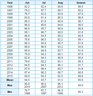
 Taking a look at the data just one more way.. here is table of the monthly mean maximum temperature for the Reno airport. Looking at July you can see that the monthly mean temperature for July was just below 90 degrees for 2015! Looking at this table this hadn't happened since 1997, so it really is reflective of just how much cloud cover and thunderstorms that we had in the local Reno area this past July. If you are interested in digging into more climate data be sure to check out the Climate page available on our website. There is a ton of neat data available there.


In other news, it really is starting to feel like fall out there! Did anyone see the snow on top of the mountains this morning? Although it does look like we will be warming up again going into the weekend. For all the forecast details please check out the discussion. Thanks!


