Hiking in the High Sierra? Attn: PCT through hikers!
Let's Talk Total Snow Amounts
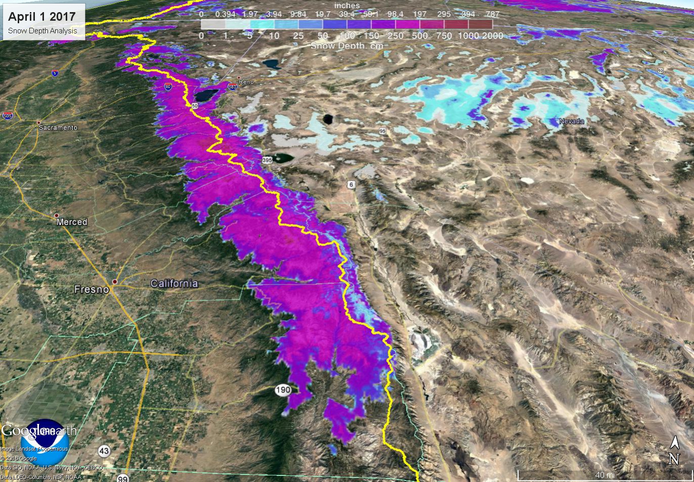
- Our reliable snowfall measurement sites in the Sierra, certainly near the PCT, are very limited. So it would be better to show a map of snow depth using automated sensors and satellite data. This was taken on April 1, typical peak snowpack date. Values of 16-25 feet were fairly common along the PCT from near Tahoe to southwest of Bishop!
Here’s June 8th's plot for comparisonYellow line = PCT
- Mammoth Mountain in January alone received 20.5 feet of snow, earning the month the Twitter hashtag #januburied.
- Of course snowfall was variable, but on a big picture this was a particularly impressive season for the Sierra from Tahoe to Bishop. The section between Tioga/Tuolumne and Sonora Passes got particularly crushed. That’s where some of the deepest snowpack still exists. A snow measurement by Jeff Anderson, NRCS, and Tim Bardsley, NWS, made just Tuesday at Leavitt Lake near Sonora Pass - 15 feet deep, containing 102.5 inches of water content!!
- This is the area where numerous strong atmospheric rivers brought large amounts of snow to areas above 8,000 feet. Much of the snow fell in a short period of time - late January through February. Earlier in the winter the storms were much warmer, with more rain and less snow.
- From a meteorologist perspective, this was probably a “once in a career” winter - with relentless blizzards, floods, wind storms, ice, and even critical fire weather conditions. At least we certainly are crossing our fingers it’s a once in a career winter...
- Right now - Big gradient in snowpack. Still have 30-40% of peak snowpack left in many areas above 8000’, with some spots of 60-80% left at snow-favored or higher elevation NRCS SNOTEL sites (e.g. Leavitt Lake, Mt Rose, Independence). Right now Leavitt Lake is at 175% of the normal year-round peak! Conversely, below 8000’ snowpack has eroded considerably.
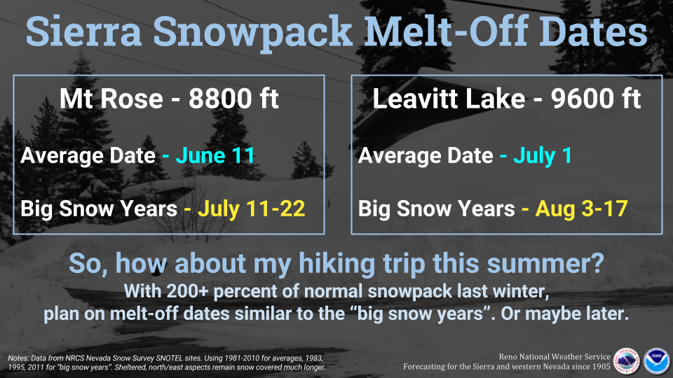
- We’re likely looking at a 4-6 week delay in snow meltoff at the highest elevations. Based on the previous big snow years of 1982-83, 1994-95, 2010-11.
Let's Talk PCT...
- We can’t directly make a comparison to the entire timeframe the trail has been official but this winter is clearly one of the bigger ones we’ve seen in 2-3 decades. Snowpack was 200-250% of normal! More than double normal, which makes for a striking contrast to the peak-drought winter of 2014-15 with snowpack 1/4 of normal in many areas!
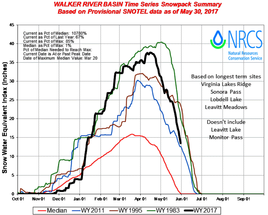
- We use 1982-83, 1994-95, and 2010-11 as comparative years on snowpack due to overall similarities, but each of those years has some contrasts to this big snow year 2016-17. Note that 1968-69 was also an enormous snowpack year, similar to 1983 and 2017, but we have very limited data to make comparison with. 1969 is the one long-time locals talk about around Mammoth and Bishop.
- The graph below shows snowpack trends for those years compared to 2016-17 for the region around Sonora Pass. In general for the Sierra the snow situation was close to 1982-83, but in many cases not as quite as big due to warmer temperatures limiting snow accumulations early on in winter. Spring this year was also not as big for snow as 1983 and 1995.
- 2016-17 winter started off quite warm, at least until mid-January. So until then we were actually still in a “snow drought” with more rain and less snow. Then the pattern shifted colder and brought more snow to lower elevations.
- This overall theme created a big vertical gradient in snowpack - areas above 8000-8500’ were plastered with big snow pretty much all winter while areas below 8000’ were more variable. As a result, snowpack below 8000’ has decreased rapidly with spring/summer sun, while above 8000-8500’ it remains quite thick. This spring’s temperatures has also slowed the snowmelt some above 8000’ with “roller coaster” temperatures peeling off the snowpack in a slow, methodical fashion. Good news for flooding concerns, but bad news for quickly getting rid of the snow along the PCT trail.
- The analog winters had similar snowpacks at some point but those winters were also colder with more snowpack at lower/mid elevations and also tended to have more snow in spring compared to this year. 2016-17 snowpack set records for peak values this year but confined to above 8000’. Below 8000’ while snow depth was considerable it largely did not set records set in those previous big winters, due to warmer temperatures and more rain.
Source: Jeff Anderson, NRCS - So overall our assessment is that this will certainly be one of the rougher seasons to be on the trail in the Sierra at least through July. The worst? Maybe. Maybe not. There are other factors (noted following) that could add to the complications of hiking the PCT this summer.

Other Stuff Worth Noting
- The prolonged deep snowpack by itself will present enormous challenges to hikers in the Sierra at least through July, and probably into August at the highest elevations. There is evidence of huge drifts and cornices remaining along the Sierra crest on the leeward sides of ridges. These are quite dangerous. Caltrans continues to plow the mountain passes and has encountered drifts on the order of 50 feet along Tioga Pass earlier in April-May. Could end up being one of the latest openings on record.
- But there are other concerns too --
- The amount of intense wind events this winter (Squaw hit 199 mph at one point & Mammoth Mountain had several cases of gusts over 150 mph) will create a ton of tree damage on the trails. Fallen trees will be numerous. Those that didn’t fall could be weakened where even just a moderate wind this summer would tip them over. Wet ground also contributes to more falling trees with shallow root systems.
- Large amounts of water will be flowing from snowmelt. Not a surprise! Creek crossings will be numerous and flowing much later than normal - perhaps all summer. Crossings will also be larger/deeper with more swift water that can easily catch inexperienced folks off-guard. On a positive note, running short on water during the hot summer shouldn’t be a problem.
- The snow covered trails and frequent high water crossings are likely to result in increased instances of search and rescue for local public safety agencies this summer.
- Bugs, mosquitos are likely to be an extra nuisance this summer due to the copious amounts of water around. We’re already seeing that around Reno.
Be safe out on the trails this summer and make sure you are prepared or at least have some intel from fellow hikers on the conditions of the high Sierra trails. For up-to-date weather information along the PCT be sure to follow one of the many National Weather Service Offices that forecast along the trail. You can find an NWS social media site using this interface.
Happy Hiking!


