El Nino: Recent Science and Forecast For Winter 2018-2019
SUMMARY POINTS:
1. EL NINO DOES NOT ALWAYS MEAN A WET WINTER FOR CALIFORNIA! Warming of the tropical Pacific Ocean with El Nino (or cooling with La Nina) is one of the only predictable features for seasonal (beyond 1-2 months) precipitation forecasting. Climate scientists know there are other features that affect winter precipitation; however, they are not predictable beyond a couple weeks or so. Depending on El Nino/La Nina alone can lead to large seasonal forecasting errors for California winter precipitation.
2. EL NINO NOT USUALLY MUCH HELP PREDICTING WINTER PRECIPITATION IN NORTHEAST CALIFORNIA AND WESTERN NEVADA. A weak-moderate El Nino is expected for the winter of 2018-2019. That strength El Nino does not provide much help for forecasting winter precipitation for the northern and central Sierra, northeast California, and western Nevada...with only the strongest El Nino events nudging chances for higher precipitation up slightly. Therefore, there are equal chances for above, near normal, or below normal precipitation this winter.
* Read on if you want more in-depth details!
____________________________________________________________________
The above average water temperatures of the central and eastern tropical Pacific Ocean associated with El Nino increases the area of tropical thunderstorm formation in that region. In turn, the thunderstorms affect the position (extending it closer to North America) and strength of the mid-latitude jet stream and storm track across the Pacific Ocean and into North America. Here are the usual winter effects of the jet stream extension:


RECENT SCIENCE REGARDING EL NINO:
During the winter of 2015-2016, there was a very strong El Nino event...in fact, one of the strongest since the 1950s. Based on previous experiences with very strong El Nino winters, precipitation chances in much of California was favored to be above average (image below). For much of the Sierra and western Nevada, there was only a slight increase at best in the chances for above normal precipitation.
So what actually happened? Southern California actually received MUCH below normal precipitation (below)...the most unlikely scenario according the forecast from the Climate Prediction Center! For western Nevada and northeast California, precipitation between November and March wound up near or slightly above average...not too out of line from previous strong El Nino events.
Recent research has tried to figure out what caused the shift in the expected pattern in central and southern California. One paper has suggested that abnormally warm waters over the North Pacific Ocean and unpredictable atmospheric patterns unrelated to El Nino may have caused the shift in wetter weather from southern California to the Pacific Northwest. In any case, it is good to remember that there are still missing pieces to the seasonal forecasting puzzle. In addition, the Climate Prediction Center's forecasts highlight probabilities/chances for certain climate conditions to occur. There are no guarantees, especially with the current lack of predictability for some atmospheric conditions beyond a couple weeks.
FORECAST FOR WINTER 2018-2019:
It may come as no surprise, but based on what we have discussed the forecast of a weak to moderate El Nino doesn't tell us much about the potential for winter precipitation across the Sierra, northeast California, and western Nevada. With the main seasonal forecasting tool that is El Nino/La Nina not helping much historically, there is little to hang one's hat on regarding winter precipitation in the area.
The El Nino is predicted to be weak enough that even southern California isn't showing a tendency towards above average precipitation at this time.
SIDE NOTE: While there aren't a lot of signals to help with forecasting rain and snow on the seasonal (several months out) scale in our area, there is research showing the potential for predicting when chances are increased for atmospheric rivers / moisture plumes out to perhaps 2-3 weeks. As strong atmospheric rivers can cause travel issues, bring heavy rain and snow, and increase flooding concerns, being prepared well ahead of time could be of major importance to many government and private entities.
_________________________________________________________________________________
SOURCES:
The California Weather Blog: (September 18, 2018)
National Weather Service's Climate Prediction Center
NOAA's Earth System Research Laboratory
Western Regional Climate Center
1. EL NINO DOES NOT ALWAYS MEAN A WET WINTER FOR CALIFORNIA! Warming of the tropical Pacific Ocean with El Nino (or cooling with La Nina) is one of the only predictable features for seasonal (beyond 1-2 months) precipitation forecasting. Climate scientists know there are other features that affect winter precipitation; however, they are not predictable beyond a couple weeks or so. Depending on El Nino/La Nina alone can lead to large seasonal forecasting errors for California winter precipitation.
2. EL NINO NOT USUALLY MUCH HELP PREDICTING WINTER PRECIPITATION IN NORTHEAST CALIFORNIA AND WESTERN NEVADA. A weak-moderate El Nino is expected for the winter of 2018-2019. That strength El Nino does not provide much help for forecasting winter precipitation for the northern and central Sierra, northeast California, and western Nevada...with only the strongest El Nino events nudging chances for higher precipitation up slightly. Therefore, there are equal chances for above, near normal, or below normal precipitation this winter.
* Read on if you want more in-depth details!
____________________________________________________________________
The above average water temperatures of the central and eastern tropical Pacific Ocean associated with El Nino increases the area of tropical thunderstorm formation in that region. In turn, the thunderstorms affect the position (extending it closer to North America) and strength of the mid-latitude jet stream and storm track across the Pacific Ocean and into North America. Here are the usual winter effects of the jet stream extension:

The stronger the warming/El Nino has historically meant that the effects were more predictable. For strong El Nino events between 1957 and 1998, here is a map showing the typical precipitation changes from normal between November and March. As you can see, for strong El Nino events up until 1998, California has seen much wetter than normal conditions...with slightly above normal conditions spreading farther east into the Desert Southwest, the Sierra, and far northeast California.

As you will see below, this concept was thrown for a loop for the 2015-16 winter which featured a very strong El Nino. Remember, as was stated at the beginning of this article, depending on El Nino/La Nina alone can lead to large seasonal forecasting errors for winter precipitation.
___________________________________________________________________________
RECENT SCIENCE REGARDING EL NINO:
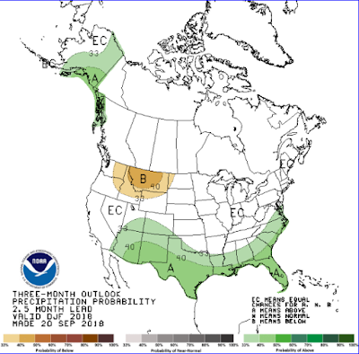
During the winter of 2015-2016, there was a very strong El Nino event...in fact, one of the strongest since the 1950s. Based on previous experiences with very strong El Nino winters, precipitation chances in much of California was favored to be above average (image below). For much of the Sierra and western Nevada, there was only a slight increase at best in the chances for above normal precipitation.
 |
| December 2015 - February 2016 Climate Prediction Center Forecast |
So what actually happened? Southern California actually received MUCH below normal precipitation (below)...the most unlikely scenario according the forecast from the Climate Prediction Center! For western Nevada and northeast California, precipitation between November and March wound up near or slightly above average...not too out of line from previous strong El Nino events.
 |
| November 2015 - March 2016 Precipitation Compared to Normal |
Recent research has tried to figure out what caused the shift in the expected pattern in central and southern California. One paper has suggested that abnormally warm waters over the North Pacific Ocean and unpredictable atmospheric patterns unrelated to El Nino may have caused the shift in wetter weather from southern California to the Pacific Northwest. In any case, it is good to remember that there are still missing pieces to the seasonal forecasting puzzle. In addition, the Climate Prediction Center's forecasts highlight probabilities/chances for certain climate conditions to occur. There are no guarantees, especially with the current lack of predictability for some atmospheric conditions beyond a couple weeks.
FORECAST FOR WINTER 2018-2019:
It may come as no surprise, but based on what we have discussed the forecast of a weak to moderate El Nino doesn't tell us much about the potential for winter precipitation across the Sierra, northeast California, and western Nevada. With the main seasonal forecasting tool that is El Nino/La Nina not helping much historically, there is little to hang one's hat on regarding winter precipitation in the area.
The El Nino is predicted to be weak enough that even southern California isn't showing a tendency towards above average precipitation at this time.

SIDE NOTE: While there aren't a lot of signals to help with forecasting rain and snow on the seasonal (several months out) scale in our area, there is research showing the potential for predicting when chances are increased for atmospheric rivers / moisture plumes out to perhaps 2-3 weeks. As strong atmospheric rivers can cause travel issues, bring heavy rain and snow, and increase flooding concerns, being prepared well ahead of time could be of major importance to many government and private entities.
_________________________________________________________________________________
SOURCES:
The California Weather Blog: (September 18, 2018)
National Weather Service's Climate Prediction Center
NOAA's Earth System Research Laboratory
Western Regional Climate Center


