Posts

Showing posts from 2016

Top 5 Things People Say to Meteorologists

Image
Credit: Perceptionvsfact.com Since the NWS has ventured out into the social media realm, we tend to get WAY more questions and comments than back in the day. Many of these questions or comments are repeated so often that we figured we should try to demystify some of them. So here are the top 5 things people say to meteorologists and here are some facts to clear up the confusion. Enjoy! 1.  "Wish I could get paid to be wrong all the time," We know it may be hard to believe, but weather forecasting has come a LONG way over the past 20 years. Even over the past 5 years, substantial advances have been made to forecast dangerous weather. Now, can we predict exactly what is going to occur a week from now? Probably not, but we can give you a pretty good idea of what you can expect, especially over the next 48 hours. Predicting the exact location and timing of thunderstorms can be super tricky, but there are high resolution models being developed that will help us to do o

Windy Week Ahead

Image
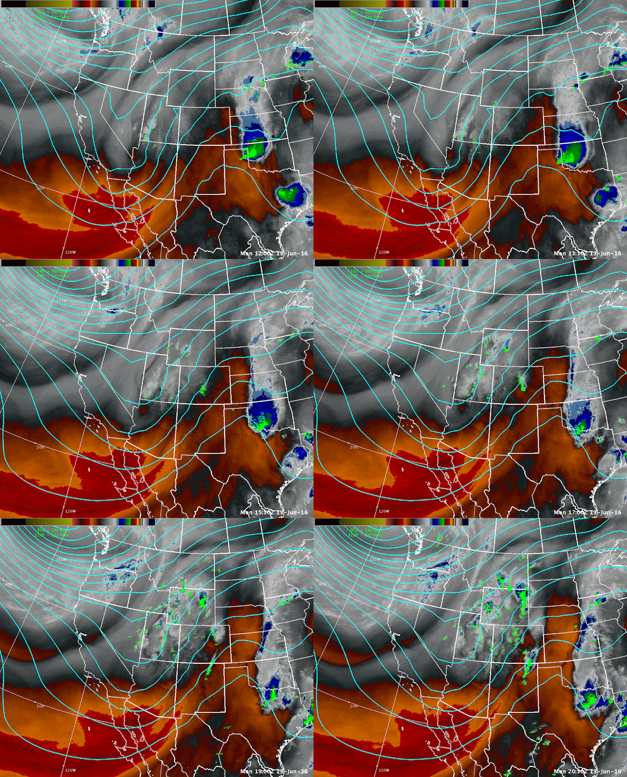
Water vapor satellite imagery from June 13th. It has been a bit of an unusual summer thus far. Although June started out hot and unusually dry, the temperatures have moderated quite a bit. As of late we had quite a bit of  rain  as well as snow across Mono and Mineral counties this past weekend as a cold area of low pressure trekked across the West. Southern parts of Mono County received a good dousing of rain through the overnight hours of the 11th into the morning of the 12th with some portions of the southwest part of the county recording more than 1 inch of rain. Snow was reported down to 9000 feet in the heavier showers and thunderstorms with up to 3 inches reported near the summit of Mammoth Mountain above 10,500 feet. Webcam photos are from June Mountain (~9,200 ft), Mammoth Mountain Main Lodge (8900 feet), and Mammoth Sesame Snow Study (9014 feet). Now we are looking at a trough pushing into the Pacific Northwest that will bring windy conditions across the Sierra

Welcome to Summer! (and soon-to-be fire season)

Image
Wow. We have been MIA for a little while!  Hope you all haven't missed us too much ;-) We have only just started meteorological summer and the wildfires have already started popping up here and there. Just in the past week we have dealt with at least 3 in the local area, with a couple of them a little too close for comfort to the NWS Reno office (two fires on highway 395 near the Parr exits in Reno). Photo Courtesy of Reno Fire Department Facebook Page So we aren't fire fighters or fuels specialists, but here at the NWS we do have to stay in tune with the fuels status so we can be ready for the fire season. Namely, if the fuels aren't ready, then we aren't issuing Red Flag Warnings. Whoa whoa whoa... what is a red flag warning? Check out this short video and it will cover the basics. So as the video stated (you should really take the time to watch it), we at the NWS have to coordinate with our local fire partners to issue Red Flag Warnings for when the fuels

How Are National Weather Service Storm Reports Used?

Image
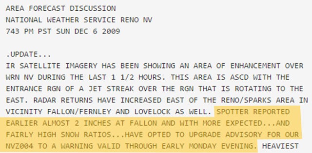
For many years, the National Weather Service (NWS) has relied on spotter/public storm reports to help in the issuing of critical weather statements, verifying warnings and advisories, and to document the impacts of weather on life and property.  In recent years, posts on Facebook and Twitter  which contain photos or videos have helped to streamline the event verification process across northeast California and western Nevada. Remember, "a picture (or video) is worth a thousand words!" So...what are some of the ways NWS storm reports are used and distributed?  Most immediately, storm reports help NWS forecasters decide whether to update the forecast or issue a statement... as can be seen from the Area Forecast Discussion below. A second use for storm/spotter reports is verification of National Weather Service watches and warnings. Below is a map with NWS warnings (red boxes) overlaid with storm reports. Besides helping forecasters glean whether or not warnings w

Wet Weather Returns for the Weekend

Image
Wet Weather this weekend? Where is it coming from? We start off this week relatively quiet as high pressure builds across the region. However, the main forecast item of interest turns to our next potential winter storm this weekend. If you have been reading our recent forecast discussions ,  you've read about the potential for a deep layer of moisture in the atmosphere to make its way across to the West Coast this weekend. These plumes of moisture are known by several different names such as " Atmospheric Rivers " or a "Pineapple Express " due to their ability to transport large amounts of moisture from tropics near Hawaii to the West Coast.  We often use the term Atmospheric River or (AR) for short in some of our forecast discussions. Figure 1:  Loop of Total Precipitable Water from Jan 22-Jan 25, 2016. Courtesy of CIMSS/University of Wisconsin-Madison The animated gif above shows a loop of "Total Precipitable Water" (TPW) over the

The Sticky Situation with Snow Levels

Image
Another wintry day in Reno with snow levels down to valley floors, which means it was likely a slower and slicker commute for most this morning. Even with my all wheel drive vehicle I lost traction a couple of times. As the traffic signs were suggesting... Anyways, back to the snow level forecast. Snow levels are one of those forecast parameters that can be very tricky to pin down, and yet can have a significant impact to the overall weather conditions! Snow levels will play a key role in the forecast through the weekend, especially since it looks like northern California and western Nevada will be caught up in a very wet pattern. Check out the details in the latest forecast discussion here .  What is the snow level exactly? Think of it as the rain-snow line. We define it as the level at which precipitation is turning into snow, so there may be some rain mixed in there as well, and it isn't where snow starts to accumulate either. So when we are trying to determine where

[Guest Post x 2] Prescribed Fire and Air Quality in Washoe County

Image
Enjoy this double guest post by Washoe County Health District Air Quality Management Division and the North Lake Tahoe Fire Protection District. They are key partners that work with us throughout the year and we all coordinate with each other for fire, air quality, and weather related concerns. Enjoy! -     -     -     -     -     - Washoe County Health District Air Quality Management Division The Washoe County Health District Air Quality Management Division  works closely with local Land Managers to conduct Prescribed Fire treatment to our lands. As part of our Smoke Management Program, we have guidelines in place for Land Managers to follow when writing their burn plans, preparing for a prescribed fire, and the day of the burn. Smoke from prescribed fires does not impact our air quality like wildfires do. As discussed in the Wildfire Smoke in Northern Nevada blog post , particulate matter (PM10 and PM2.5) are found in smoke. As part of the guidelines for prescribed bu