Return of Monsoon Moisture and what is Dry Lightning?
Hey all! Looks like we are transitioning into a more active thunderstorm pattern once again. High pressure over the desert southwest will bring above normal temperatures for the next few days. Increasing moisture and instability will bring chances for thunderstorms Friday through Monday, mainly for the Sierra and for far western Nevada. Gusty outflow winds and lightning fire starts are the main concerns for Friday and Saturday with locally heavy rain possible by the weekend.
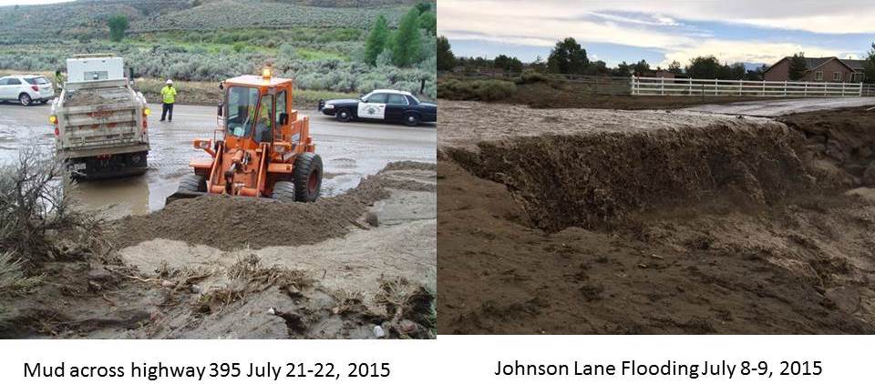
Just to be clear though, this monsoon push will not be like the one we experienced earlier in July. Although there could be some localized flooding we are not expecting multiple areas of flash flooding. Why?
The moisture associated with this southeasterly flow will not have remnants of a tropical storm with it (Dolores in early July) and moisture doesn't appear to stick around as long as last time. It looks like southwesterly flow should return by sometime next week which will really dry out the region and limit showers and thunderstorms from continuing.
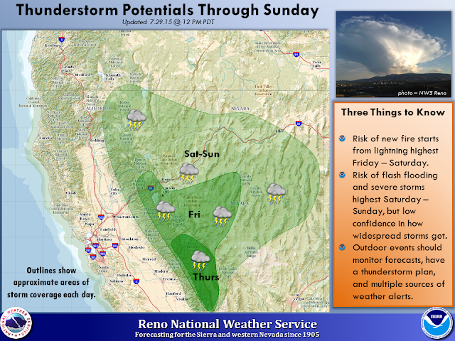

Showing the current visible satellite imagery from this morning, the monsoonal moisture is slowly making its way northward through California and southern Nevada. Notice the lightning strikes even this morning at 11:30AM. The graphic above shows that increasing chances for thunderstorms through the weekend and into early next week. Those with outdoor plans and activities should be sure to have a contingency plan for the possibility of lightning, gusty winds, and heavy rain by early next week. For the most up-to-date forecast please go here.
So let's talk about lightning. Sometimes you will hear (or read) the forecasters here at NWS Reno refer to lightning or storms as 'dry lightning' or 'dry thunderstorms'. So what does that mean? In simplest terms it just means that lightning strikes are occurring without significant precipitation. So it isn't actually a reference to the type of lightning, but the type of storm that the lightning is associated with. The National Weather Service classifies a dry thunderstorm as a storm that produces less than a tenth of precipitation over an area. These types of storms are typical during the summer in the eastern Sierra and western Nevada, especially during the first couple days of a monsoon push. Dry lightning or dry thunderstorms are of great concern to the fire community as lightning with little to no rain can result in fire starts. Here is an example of a forecast sounding that would indicate the potential for dry lightning. If you need a refresher on looking at a Skew-t sounding go here.
 There are a couple of things to note in this sounding. Precipitable water values with this sounding (not shown) are at 0.61 inches, which will likely be enough to produce thunderstorms, but right around average for this time of year. The main components of the sounding that would leave us to think of dry thunderstorms are the dry sub-cloud layer and the relatively fast winds in the steering layer. The more extensive the sub-cloud layer, the more difficult it is for the rain to moisten it and reach the ground, which commonly shows up as virga and/or dry microbursts. Also fast moving storms don't have as much time to put down rain on a particular point, so storms end up being on the dry side.
For the upcoming forecast we are expecting a mix of wet and dry thunderstorms, so while there will be some dry lightning we are not expecting a widespread lightning event that will start multiple fires. Remember that no where is safe outdoors when there is lightning. Lightning fatalities are up this year, so don't become a statistic! For more information on lightning safety, take some time to check out www.weather.gov/lightning

Official forecast discussion here.

For the upcoming forecast we are expecting a mix of wet and dry thunderstorms, so while there will be some dry lightning we are not expecting a widespread lightning event that will start multiple fires. Remember that no where is safe outdoors when there is lightning. Lightning fatalities are up this year, so don't become a statistic! For more information on lightning safety, take some time to check out www.weather.gov/lightning
Official forecast discussion here.


