Tools of the trade (Skew-T Soundings)
I am sure that some of you have seen the entertaining videos of weather balloon releases that we have done at the NWS office, or maybe you have been lucky enough to be here in person when the balloon launch occurs. But what happens with this data and how does it assist us with predicting weather? Since we have already had thunderstorms this year (June came early), let's focus on how we utilize the weather balloon data to determine the potential for thunderstorms.
Let's start from the beginning...Everyday one of our meteorologists releases a balloon at 11Z and 23Z. You are probably thinking 'Z?' Well it is called 'Zulu' time which you might know as 'GMT' (Greenwich Mean Time). It is a standard measure of time we utilize here at the Weather Service offices to ensure all of our data and products get issued around the same time of day worldwide. All balloon launches world-wide are released at 11Z and 23Z! Anyways, back to the balloon launch.
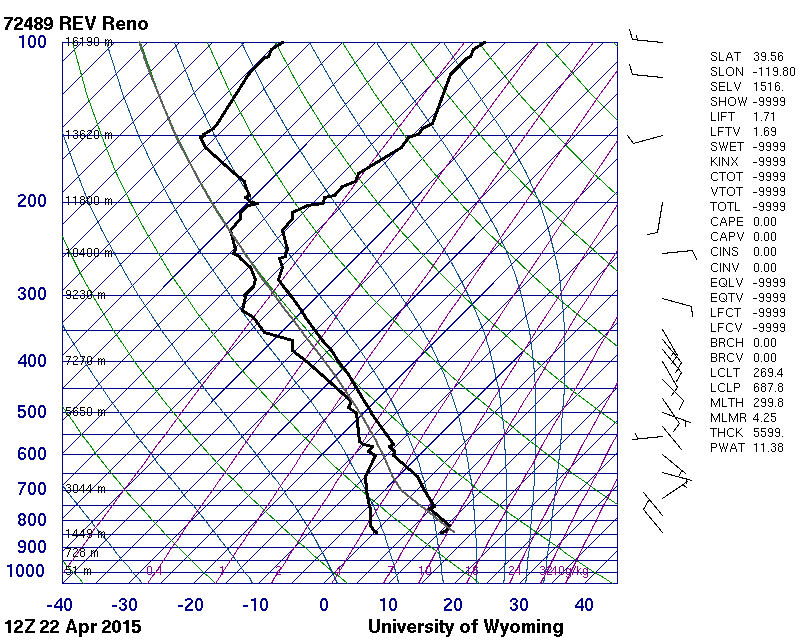
Not only does the data from the balloon get ingested into the forecast models around the world, but we can analyze it to get an idea of the structure of the atmosphere around Reno-Tahoe. On the day shift, we analyze the morning sounding, also known as the 12Z sounding. The morning sounding gives us an idea of what the existing state of the atmosphere looks like and then we can attempt to extrapolate what it will be in the afternoon. Let's take a look at a sounding from April 22nd which turned out to be a fairly decent thunderstorm day.
Generally, there are 3 things necessary for thunderstorm development - Moisture, Instability, Lift. We will try to focus on those primary ingredients when analyzing our sounding. Let's first see if we have sufficient moisture. There are a couple of different ways to determine the moisture in the sounding. First just by looking at the lines, what you can't tell? Let me explain.
The main lines on the chart represent the dry-bulb temperature (red) and the dewpoint temperature (green). The closer the lines are together the closer the atmosphere is (at that height) to saturation. Basically when the dewpoint temperature = the dry-bulb temperature you have 100% humidity (saturation) which could result in the formation of a cloud. So just glancing at the sounding below, it appears that we have quite a bit of moisture in the atmosphere the morning of April 22nd. Another way that we can determine the moisture content of the soundings by looking at the precipitable water value (PWAT). The sounding contains around 0.45 inches of moisture, which is a slightly above average for late April (average 0.3 inches)
So it looks like we can check moisture off of our ingredient list. Let's see if the sounding will show enough instability. Instability occurs when a parcel of air is warmer than the environmental air and rises on its own due to positive buoyancy. Just like how a hot air balloon would rise on chilly September mornings in Reno. Instability is often expressed using positive CAPE (Convective Available Potential Energy) or negative LI (Lifted Index) values. Both of those values can be calculated from the sounding. The values off the 12z sounding that morning were -2.8 for the LI and 707 J/Kg (joules per kilogram...which is a unit of energy per unit mass). These values are impressive for around here, but nothing compared to the big severe weather outbreaks in the plains where CAPE values can exceed 4000 J/Kg and LI's can be -10 to -12!
Another thing you can look at to determine stability is the tilt of the temperature curve in relation to the dry adiabat and the moist adiabat. Now...what the heck is an adiabat? An adiabatic process makes the assumption there is no transfer of heat or matter between a system and its surroundings. In the atmosphere there is something known as the "adiabatic lapse rate". Imagine filling an invisible balloon with air, and now we will call this our air parcel. If we were to raise the parcel in the atmosphere, pressure would decrease, causing the volume to increase and the temperature to decrease to hold steady with the ideal gas law. This is known as the dry adiabatic lapse rate and assumes an unsaturated parcel. The average dry adiabatic lapse rate is 5.5 degrees F per 1000 feet of lift. Now what about when the parcel cools to the point of saturation, i.e. the temperature of the air parcel now is the same as the dew point. At this point, the moisture condenses and this process actually releases heat through the latent heat of condensation. Therefore the moist adiabatic lapse rate is only 3 degrees F per 1000 feet of lift. All those background lines on the skew-T diagram aren't just there to play tricks on your eyes...they actually all mean something. Here is how it breaks down with the dry and moist adiabats:
So, now that we can recognize the lines which represent dry and moist adiabats, we can compare the environmental lapse rate (the actual measurements from the weather balloon) to these lines to see layers of the atmosphere that may be unstable. If the environmental lapse rate is less than the moist adiabatic lapse rate, then the atmosphere is stable. On the other side of the spectrum, it is unstable if the environmental lapse rate is greater than the dry adiabatic lapse rate. If the environmental lapse rate falls between the two, then the environment is considered conditionally unstable and we have to investigate other items to access the potential instability. Here is an example:
So, looking at the features in our sounding from the morning of April 22, we can see that there is instability present. Check!
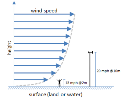
Now onto lift! Around here we have tons of mountains which can provide the necessary lift for thunderstorm development. Other sources of lift may include cold fronts or natural convergence zones as wind flows around the topography as shown in the image below. The reality is that we have a source of lift most days around here...check!
So there you have it, we were able to use the data from our upper air balloon to deduce the development of thunderstorms in the area. Pretty cool, right? If you are ever around north Reno 3 am/pm PST or 4 am/pm PDT, take a look and you might just see that balloon taking flight over the city!
There are actually chances for thunderstorms in the forecast for this afternoon! Be sure to read the Forecast Discussion for more details and check out the afternoon sounding after 5pm to see what it looks like!
Note for sounding webpage: Make sure to select GIF: Skew T under Type of Plot and click on REV on the map.
Let's start from the beginning...Everyday one of our meteorologists releases a balloon at 11Z and 23Z. You are probably thinking 'Z?' Well it is called 'Zulu' time which you might know as 'GMT' (Greenwich Mean Time). It is a standard measure of time we utilize here at the Weather Service offices to ensure all of our data and products get issued around the same time of day worldwide. All balloon launches world-wide are released at 11Z and 23Z! Anyways, back to the balloon launch.
Not only does the data from the balloon get ingested into the forecast models around the world, but we can analyze it to get an idea of the structure of the atmosphere around Reno-Tahoe. On the day shift, we analyze the morning sounding, also known as the 12Z sounding. The morning sounding gives us an idea of what the existing state of the atmosphere looks like and then we can attempt to extrapolate what it will be in the afternoon. Let's take a look at a sounding from April 22nd which turned out to be a fairly decent thunderstorm day.
Generally, there are 3 things necessary for thunderstorm development - Moisture, Instability, Lift. We will try to focus on those primary ingredients when analyzing our sounding. Let's first see if we have sufficient moisture. There are a couple of different ways to determine the moisture in the sounding. First just by looking at the lines, what you can't tell? Let me explain.
The main lines on the chart represent the dry-bulb temperature (red) and the dewpoint temperature (green). The closer the lines are together the closer the atmosphere is (at that height) to saturation. Basically when the dewpoint temperature = the dry-bulb temperature you have 100% humidity (saturation) which could result in the formation of a cloud. So just glancing at the sounding below, it appears that we have quite a bit of moisture in the atmosphere the morning of April 22nd. Another way that we can determine the moisture content of the soundings by looking at the precipitable water value (PWAT). The sounding contains around 0.45 inches of moisture, which is a slightly above average for late April (average 0.3 inches)
Another thing you can look at to determine stability is the tilt of the temperature curve in relation to the dry adiabat and the moist adiabat. Now...what the heck is an adiabat? An adiabatic process makes the assumption there is no transfer of heat or matter between a system and its surroundings. In the atmosphere there is something known as the "adiabatic lapse rate". Imagine filling an invisible balloon with air, and now we will call this our air parcel. If we were to raise the parcel in the atmosphere, pressure would decrease, causing the volume to increase and the temperature to decrease to hold steady with the ideal gas law. This is known as the dry adiabatic lapse rate and assumes an unsaturated parcel. The average dry adiabatic lapse rate is 5.5 degrees F per 1000 feet of lift. Now what about when the parcel cools to the point of saturation, i.e. the temperature of the air parcel now is the same as the dew point. At this point, the moisture condenses and this process actually releases heat through the latent heat of condensation. Therefore the moist adiabatic lapse rate is only 3 degrees F per 1000 feet of lift. All those background lines on the skew-T diagram aren't just there to play tricks on your eyes...they actually all mean something. Here is how it breaks down with the dry and moist adiabats:
So, looking at the features in our sounding from the morning of April 22, we can see that there is instability present. Check!
Now onto lift! Around here we have tons of mountains which can provide the necessary lift for thunderstorm development. Other sources of lift may include cold fronts or natural convergence zones as wind flows around the topography as shown in the image below. The reality is that we have a source of lift most days around here...check!
 |
| Image courtesy of Wildfire Course S-290 |
So there you have it, we were able to use the data from our upper air balloon to deduce the development of thunderstorms in the area. Pretty cool, right? If you are ever around north Reno 3 am/pm PST or 4 am/pm PDT, take a look and you might just see that balloon taking flight over the city!
There are actually chances for thunderstorms in the forecast for this afternoon! Be sure to read the Forecast Discussion for more details and check out the afternoon sounding after 5pm to see what it looks like!
Note for sounding webpage: Make sure to select GIF: Skew T under Type of Plot and click on REV on the map.


